Summary
The Super Block Project is a 50/50 Joint Venture between C3 Metals and Geophysx Jamaica Ltd., the largest mineral tenure holder in the Jamaica. Entering into this joint venture gives C3 Metals exposure to the past producing Pennants Gold mine, which operated and produced 16,000 gold ounces between 2002 and 2004. The Super Block project comprises 9,870 hectares and is located west of C3 Metals' 100%-owned Bellas Gate Project, where an earn-in agreement is currently in place with Freeport-McMoRan. The project is surrounded by mineral concessions in which Barrick Gold has the right to earn an 80% joint-venture interest with Geophysx (Figure 1). Recently completed closely spaced soil and channel sampling at Super Block confirms strong gold geochemistry along trend and of similar intensity to the former Pennants Gold Mine.
The former Pennants Gold Mine operated as an open pit between 2002 and 2004. Estimated production was approximately 16,000 gold ounces (Source: Jamaica Mines and Geology Division). Pennants reported a non-compliant NI 43-101 historical mineral resource of 75,500 tonnes at 20.4 g/t gold1,2. Historical high-grade drill intersections3 from Pennants included (drill results are historical in nature and have not been independently confirmed):
- 1.7m at 430.0 g/t gold;
- 3.8m at 56.4 g/t gold;
- 4.6m at 25.6 g/t gold;
- 9.2m at 18.4 g/t gold; and
- 3.1m at 17.0 g/t gold.
1 The mineral resource cited above is presented as a historical estimate and uses historical terminology which does not conform to current National Instrument 43-101 (“NI 43-101”) standards. A qualified person has not done sufficient work to classify the historical estimate as current mineral resources or mineral reserves. Although the historical estimates are believed to be based on reasonable assumptions, these estimates were calculated prior to the implementation of NI 43-101. As these historical estimates do not meet current standards as defined under sections 1.2 and 1.3 of NI 43-101, C3 Metals is not treating the historical estimate as current mineral resources or mineral reserves.
2 Published report, Geochemical exploration for gold in Jamaica: A comparison of stream sediment and soil surveys, Geochemistry: Exploration, Environment, Analysis, 4, 161-170, 1 May 2004, authored by Robert G. Garrett, Gerald C. Lalor and Mitko Vutchkov.
3 Data from the above drill results are reported historical results and it is unknown what type of quality-control programs were performed at the time. C3 Metals’ QP also advises that true width of the above results cannot be determined at this time.
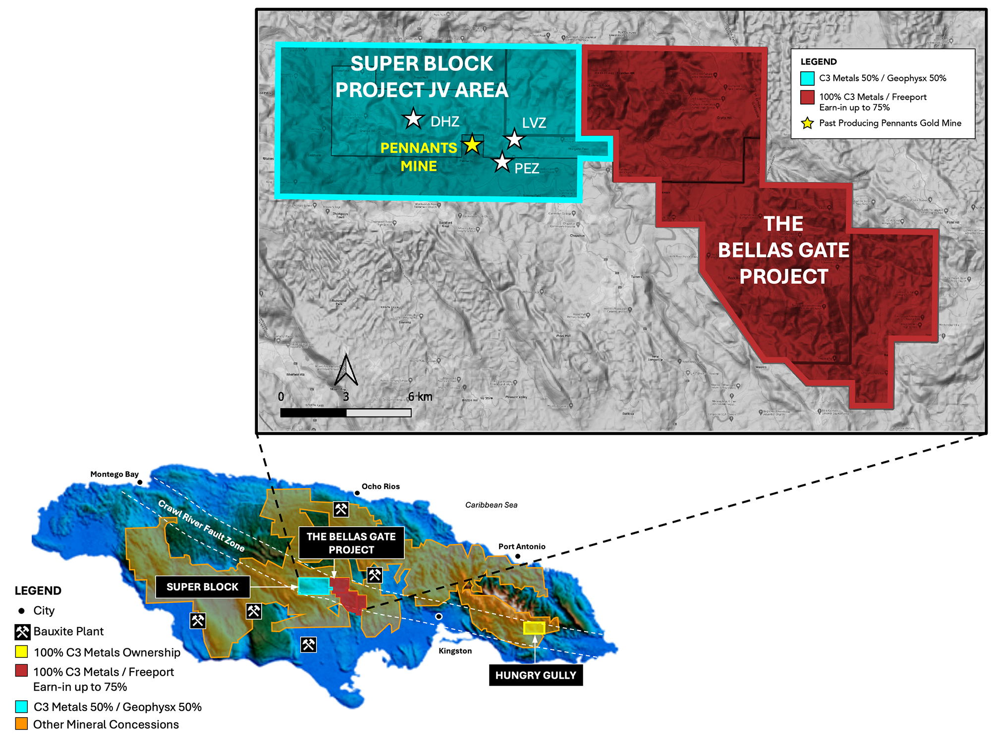 Figure 1: Map showing the Super Block project area in relation to C3 Metals' 100%-owned Arthurs Seat and Bellas Gate mineral concessions. Note the locations of the former, high-grade Pennants Gold Mine and the DHZ, PEZ and LVZ epithermal gold-silver prospects.
Geology
The geologic history of subduction, crustal thickening and tectonism has produced extensive mineralization within areas of Cretaceous rock throughout the Caribbean, such as at the Pueblo Viejo deposit, which contains more than 20 million ounces of gold reserves (Barrick Gold Corp. website as at March 31, 2023).
Super Block Project Surface Sampling Highlights:
- Anomalous gold in rocks and soils at the Super Block project are directly associated with radiometric (potassium) anomalies (Figure 2).
- Surface sampling extends the trend of gold mineralization to +5,000m and remains open in both directions along strike.
- At the Pennants East Zone prospect ("PEZ"), gold is highly anomalous in soils and coincides with a 1,500m east-west trending radiometric (potassium) anomaly.
- Best soil line results are 60m averaging 0.41 g/t gold and 103m averaging 0.20g/t gold with samples collected at 5m intervals. For reference, gold in soil assays above 0.04 g/t gold are considered anomalous.
- At the Donkey Hill Zone prospect ("DHZ"), highly anomalous gold is in weathered bedrock. It coincides with a 550m by 150m northwest-southeast trending radiometric (potassium) anomaly.
- Best channel sample result is 10m averaging 0.41 g/t gold, a combination of highly weathered rock and soil.
- A first pass 2,500m diamond drilling program is planned to commence late Q1 to early Q2 2025.
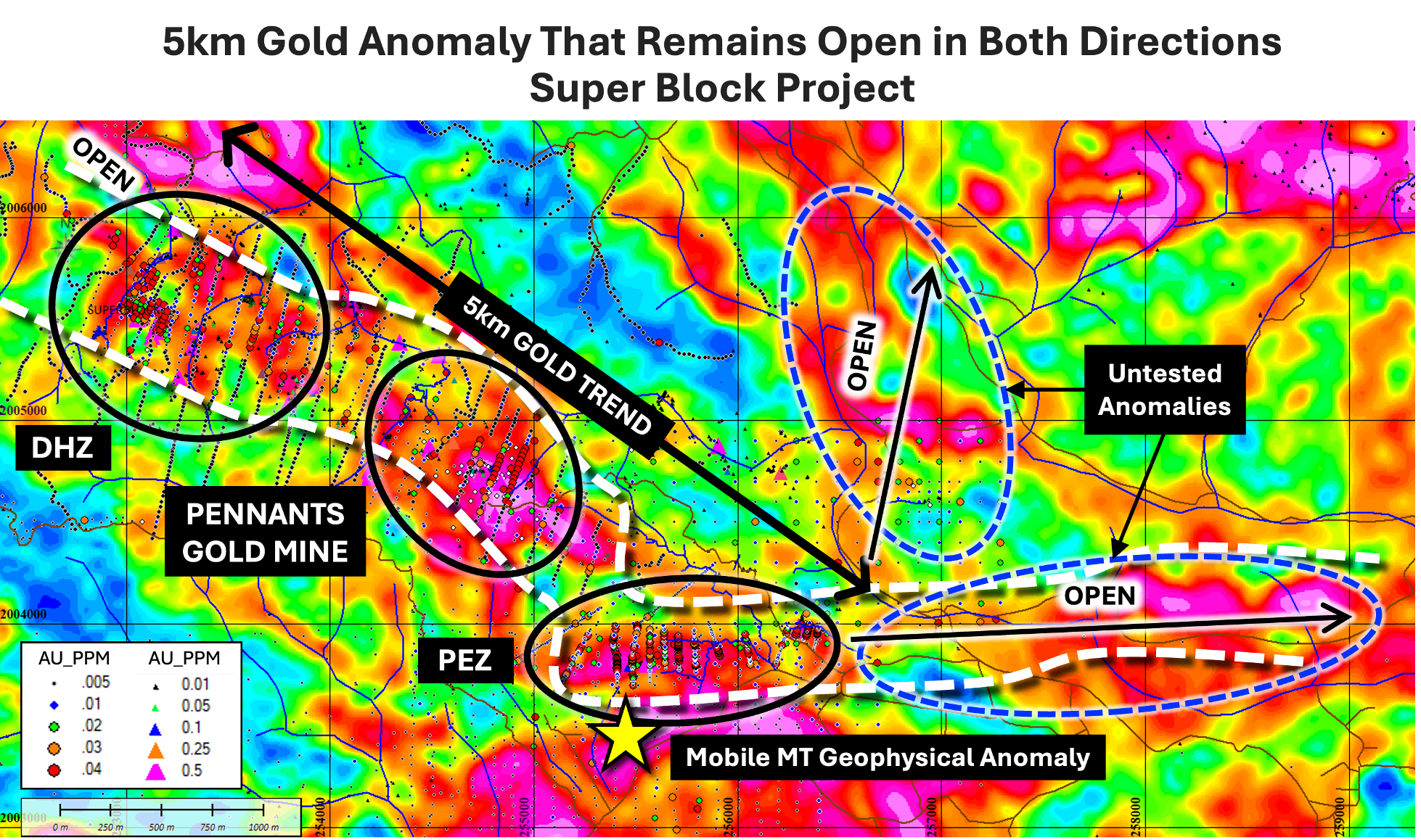 Figure 2: Airborne radiometric image (potassium) showing a strong correlation of gold in soils and rocks with radiometric anomalies. Map shows the Super Block soil line locations at DHZ and PEZ prospects.